Showing posts with label new hampshire. Show all posts

Tuesday, August 13, 2013

Purgatory Falls Nature Walk

This past weekend I had plans with Jaime to hike either Pack Monadnock or Mt. Monadnock. She mentioned wanting to "climb a mountain" a few times, and I was excited that she wanted to do something a little out of her comfort zone. The retail world has eaten up my weekends and her office job sucks up her weekdays (as well as her soul), so finding a good time to go had been difficult. I took the weekend off for my Spartan Race and foolishly figured I would be fit to hike the day after the race. Jaime was rightfully skeptical and asked "Are you sure you can hike after that? I feel like you'll be dead". Nahhhhhhh, I'll be fine, I responded with a wave of my hand.

She was right, and not that surprised when I texted her the night before asking if we could take a rain check.

The race left me bit more battered than I thought, but my muscles felt okay in the morning and I had just enough energy to be bored with sitting around. I had a slow start to the morning, but every time I sat down I felt like I was suffering from rigor mortis**.  Common knowledge said let the muscles rest, but I felt like some light activity would be good and preventing me from stiffening up. Thankfully, Jaime was flexible and agreed to come a short jaunt into nature at Purgatory Falls near my house. She was not fond of the name "Purgatory" for anything, and not surprisingly the myth of the area isn't much more upbeat. It goes as such:

Cookin' in the Devil's Beanpot
Once upon a time (don't all myths HAVE to start that way?) the Devil visited Purgatory Falls, where he made his home to watch over the people of Mont Vernon. Being the devious devil he was, he disguised himself and invited the elders of the town over for a bean supper. The elders anxiously awaited while he stirred his beans, and the Devil unknowingly conjured up too much heat and got his foot stuck in the rocks. He swore and grew very frustrated, and the elders soon realized who really was and fled. He left behind the "Devil's Beanpot", a giant hole in the middle of the rock, and the "Devil's Footprint", a 7-foot long human shaped footprint. Side note: for some reason I could not stop laughing at that old-timey man hanging out in the beanpot. I don't know, it's a slow day at work.

The Purgatory Brook Trail is one that I been on many times over the course of my life simply because it's about 5 mintues from my house. The trail is about 3 miles end-to-end, but for whatever reason I've never done a round trip. The past few years I've stuck to the Lower Falls because it's a very short walk from the trail head, but as a kid I often went to the Upper Falls where the Devil's Beanpot and Footprint are. The trail follows the Purgatory Brook and is quite easy to navigate. The ease of the trail attracts many families and can be crowded on nice days. A note on the trail though - I noticed a lot of the blazes are very faded and many of the areas are well traveled enough that the path isn't always that obvious. It is hard to get very lost, though, so even someone with no experience would find their way.

We set out towards the Lower Falls, and I made the mistake of telling Jaime there were a lot of black bears in the area. She was convinced we were doomed. Thankfully, the only wildlife we came across was a small garter snake, which is not high on the list of animals I like to see but is low on the list of animals that could rip my face off.

Taking a dive
The Lower Falls are a short walk into the woods (maybe a 1/2 mile at most). We spent most of our time at the top of the falls enjoying the sun. Everyone clap for Jaime -insert clapping here-, as she successfully navigated some precarious rocks to get to the top of the falls. She had herself convinced that every obstacle (however large or small) that was not flat ground would leave her on her ass with a twisted ankle, but she made it through just fine.

From the Lower Falls we continued on towards the Bridge (as seen above on the map). The trail followed the Brook and had a couple rocky crossings over small streams, but nothing too intense.


The Bridge crosses over the Purgatory Brook and provides for a lovely photo opportunity, as seen of my feet. We certainly had enough time to hike to the other end and come back, but I suddenly realized how hungry and tired I was. I think I spent the whole time on the bridge talking about what kinds of food I wanted to eat. The exhaustion from the race finally caught up to me, the ache in my muscles was starting to grow, and I was ready for a XL sandwich.

We did about 2 miles round trip, but it was a pleasant and easy nature walk. I want to go back soon and do the whole trail!


**Disclaimer: I know I was not ACTUALLY suffering from rigor mortis, as I was not dead. I felt the need to include that since Jaime yelled at me when I said I was going rigor mortis.

Monday, July 15, 2013

Franconia Ridge Traverse

Before

Once I set my mind on completing the White Mountain 4,000 Footer list, I thought maybe I should start with the smallest mountain - Mt. Tecumseh, 4,003 feet, still 837 feet higher than Mt. Monadnock, the highest mountain I had climbed in years. My line of thought somehow warped into choosing the sixth highest mountain in the state, the highest outside of the Presidential Range - Mt. Lafayette. I had heard good things (and later I would hear some bad things), but 5,260 feet of elevation had me worried. So, I recruited my friend Court who willingly obliged to a day-long excursion. He offered to be my hiking buddy a few weeks ago, and I was stupidly excited since he hiked a huge chunk of the AT ("I must not be THAT hopeless after all!"). I have been enjoying learning things on my own, sometimes the hard way, but I knew I could use the guidance of a more experience hiker. Plus, it would be a great way for me to get to know the guy who's been dating one of my best friends (and Facebook wife) for so long.

So, I chose Mt. Lafayette. My research turned up that it would be about a 8 mile trip up and down, or an 8.9 mile trip for the loop. I immediately started doubting my abilities. The loop consists of three mountains (though I somehow forgot this the day of... read on); the 4,800 foot Little Haystack Mountain, the 5,089 foot Mt. Lincoln, and the 5,260 ft Mt. Lafayette. To do all three is to complete the Franconia Ridge Trail, which links up to several other trails and the Greenleaf Hut along the way. My doubt started to grow as we worked out the logistics, but Court reassured that I would be fine. My NH hiking guide rated the views as a 5/5, and the difficulty as a 10/10. Oh, crap. I felt a little better that Mt. Monadnock had the same rating. But... a mountain 2,094 feet higher than the biggest mountain I've hiked in recent memory? Even more troubling: the elevation gain of Mt. Monadnock is around 2,094 feet whereas this trail was almost 4,000 feet of elevation gain. Even MORE troubling: the site I was using for reference estimated the total time would be 6.25 hours for about 9 miles. I hiked almost 17 miles in 7 hours on the Wapack Trail. In short, I knew I was in for a challenge. 

The night before I'm doing something important or exciting (first day of work, waking up for a flight, etc.) I always have a stress dream. This was no different. I was supposed to be up at 6am, and in my dream I slept until 9:30, Court was calling me to see why I had blown him off, and there was 6 inches of slush on the ground in July. "I'm so sorry, I slept in! It's supposed to be 90 degrees today, maybe the slush will melt!" None of those things happened. I was up before my alarm and we left our neck of the woods at 7:00. It's about an hour and a half drive to the White Mountains region, and after a few minutes of confusion over where the trail head was we parked among a sea of cars and prepared to set off. On the drive up we decided to change our plans from hiking up Old Bridle Path (the most direct) to taking Falling Waters Trail, a friend had suggested the Falling Waters Trail since it had, believe it or not, some lovely falling water and was less steep than Old Bridle.


During


Along the Falling Waters Trail
Hours 0 - 2: We hastily set off to avoid being stuck with a group of about 15-20 people that were converging at the trail head. No thanks. The Falling Waters Trail did not disappoint! There were some sections of high, fast moving water, but I only had a fully submerged boot once. I was carrying a ridiculously large expedition pack provided by my step dad that shifted around a little bit when I was jumping, which did not make for the most graceful leaps. My waterproof boots held up, though. It was hot and humid, and though hiking along the water provided some cool breezes we were thankful for some ice cold, crystal clear mountain water. I hesitated for a moment, envisioning myself bent over vomiting from some bacteria, but my fears were eased when I saw how clear the water was. A water fall coming out of the side of a mountain is about as safe as you can get. My mom still wasn't too happy with that, but I'm here, right?

Trail, or rock climb?
This trail was quite unforgiving, with very few stretches of flat ground and plenty of places to face plant. I wanted to keep a decent pace to prove to myself that I could do it, but also to make sure we were making good time. I'm proud to say that I did quite well! It was not without a lot of sweating and feeling like I wanted to vomit at some points. The trail is riddled with rocks and roots, so almost every step had to carefully placed. We stopped twice, once for a water break / my inability to breathe, and once so I could wrap my knee, which was starting to feel particularly wobbly. Did I mention that I strained something in my knee about a week ago? No? Well I did, and it was feeling particularly unsettled all week. Not very reassuring when you're going to be stepping over uneven rocks for 6 hours. Just before our second pit stop I said to myself "Oh, Molly, you will never hike the AT because this is miserable and why do you want to do this to yourself?" Then I ate a Chewy bar and Gatorade "energy chew" that my parents bought me for my birthday, and I suddenly felt much better. It's amazing what a little gooey square of pure corn syrup will do for morale. We finally started to see some viewpoints when we were almost at the summit (though we didn't know that), and were able to look back onto "'The Old Man In The Mountain' Mountain (RIP)", as I call it, or Cannon Mountain, as most other people call it.

Hours 2 - 4: We popped out to the summit just about 2 hours after setting out. As I mentioned before, I somehow forgot that we were going to Little Haystack Mountain and not Mt. Lincoln. In my head I had planned to do the loop in the other direction, meaning Mt. Lafayette first, and it just slipped my mind that it was three mountains and not two. I quickly realized my mistake when I saw a marker that said "Mt. Lincoln" with an arrow pointing left. I quietly cursed myself as I looked over to Mt. Lincoln, realizing that we had two more "uphill" stretches instead of one. A double-decker PB&J, Dorito's, and astounding views quickly reset my woes, though I had almost zero appetite.

View from the Summit of Little Haystack Mountain (stolen from Court)


Headed towards Mt. Lincoln
Cameras rarely do justice to what you see with your eyes, but the photo I stole from Court's much-nicer-camera comes close. We spent about 20 or 30 minutes at the summit of Little Haystack before heading towards Mt. Lincoln. The trail, though still quite rocky in some areas, was a nice change from the ascent. The rock-lined path across the ridge was easy to navigate and provided amazing views the entire way. We frequently stopped to take in our surroundings, or to await a traffic jam to clear. The path narrows significantly when it enters the trees, so it really only allows for one-way traffic. The ridge walk is almost completely exposed, and it's obvious to see how the weather could change drastically and conditions could become dangerous very quickly. Luckily, we had a mostly clear day (it was a little hazy), and we were thankful for some cloud cover so the sun wasn't beating down on us the whole time.


Looking towards Mt. Lafayette
Linking up the AT


We stopped only briefly at Mt. Lincoln, mainly so I could take my typical "here's my feet relaxing with a nice view" photo, but also because the biggest mountain, Mt. Lafayette, was next. The Franconia Ridge Trail is part of the AT, and I smiled when I saw the white blazes I knew were part of the AT. Huzzah! I started secretly hoping we would meet a thruhiker. 

Success!!
About 2 miles after we left the summit of Little Haystack Mountain we arrived at the summit of Mt. Lafayette. It was crowded and a little noisier than I would have liked, but it was incredible nonetheless. Trees looked like toothpicks, cars were just little blobs of color, even the highway looked majestic. How often can you say nice things about 93? Reaching the third summit of the day was a great feeling, but the impending blisters I was feeling were not. I didn't bother to take off my boots, but I was silently rooting for the liners I purchased from REI to do their job. Basically, the idea is that the thin, form-fitting sock liner prevents blisters by creating a sock-on-sock instead of sock-on-skin situation. My hopes were being dashed as I felt the "hot spots" forming in the usual areas, but I was distracted by a particularly rugged-looking hiker reaching the summit and yelling "Okay, who brought the beer?!"

Looking back to Mt. Lincoln (stolen from Court)
We soaked up the view for a few more minutes before beginning our descent. I realized Court wasn't directly behind me, and when I turned I heard him ask the "where's-the-beer" guy if he was a thruhiker, and he was (afterwards Court told me "that was the thruhiker smell"). My silent hopes of running into a thruhiker were answered! He was particularly cheerful and eager to chat with us for a few minutes. I asked him why he was carrying a beat-up hockey stick with him, and he said his trail name was Puck. Fair enough. He was hiking North - South and had started in Maine 42 days ago. I offered up my uneaten Snicker's, which he humbly accepted after saying "oh... oh man... only if you're willing to part with it". As I was handing it to him, "blue-shirt-man" (nicknamed so because he was wearing a blue shirt) popped out behind us and offered him a pear. We wished him well and started our descent.

Heading to the Greenleaf Hut (small, but visible!)
Hours 4 - 6ish: The first mile or so was very rocky (seems to be the theme, right?), and crowded at times. Every step had to be carefully placed, which was true for almost the entire trail, to avoid becoming a tangle of flailing limbs. My knees were a tad wobbly, my ankles were starting to ache with each step, my quads were getting a decent workout, but I kept up a decent pace. We re-entered the woods where the trail slimmed down to one-way traffic again, and just under 2 miles after the summit we reached the Greenleaf Hut. But, oh, I left out a lovely squander of mine. There's a small lake next to the Greenleaf Hut, and the trail runs adjacent to a muddy section next to the lake. I went first, jumped from one rock to the next, and then thought I was close enough to effortlessly leap to over the last bit of mud to solid ground. Well, I underestimated my ability to jump from a standstill on a rock with an awkwardly large pack on my back. My left foot plunged into the mud up to my sock line, luckily I was able to rip it out before it went any deeper. Court laughed at me as I whacked the mud off on a rock. Thankfully my waterproof boots held up and no mud got through. I immediately praised myself for purchasing gaiters with the liners the day before, otherwise I would have certainly had a boot full of mud. The Greenleaf Hut was overrun with kids, but at least it had a bathroom for those of us without outdoor plumbing. I'm not against dropping trow in the woods, but I'd rather not if there's an option.

Looking back at Mt. Lafayette (left) and Mt. Lincoln (right)
A four mile descent down Old Bridle Path seemed much longer than that, because as I mentioned before I had to really pay attention to each step. I could feel myself getting tired but I knew that if I let my guard down it could end poorly. I was very thankful for my "hiking poles" (free ski poles from the dump) and every stretch of level ground. There were a few times that I crab-crawled down some rocks, because I figured I might as well be on my ass voluntarily rather than waiting for an ill-placed step to do it for me. Thankfully I didn't have any major qualms, but I did get two decent scrapes, one on each leg, from rubbing against a rock. I made a mental note to invest in the convertible pants I had been eyeing during my clothing training at work. Pants are abrasion resistant, my skin is not.

Can you tell which foot went in the mud?
The sound of water confirmed we had linked back up to the Falling Waters Trail, meaning the loop was complete! A short .2 mile walk on mostly level ground took us to the trail head and completed our journey. We walked under the highway and back to our car, where we saw two men trying to fish something out of their car window with their trekking poles. We assumed they had locked their keys in the car, but a few minutes later they told us their father had the keys and was on his way, they just wanted to get the beer that was inside. Fair enough. I peeled off my muddy boots, gaiters, and socks, and cringed awaiting my blister-riddled fate. But alas, the liners did their job and I was blister free! Best $6 (even less with my discount) I've spent. As we were packing up the car, blue-shirt-man, the one that gave Puck a pear, approached us asking for a ride back to a trail head 3 miles down the road. He thanked us several times, saying he didn't want to have to walk three miles after having done 10 miles of hiking. I thought back to the day I completed the last stretch of the Wapack, then had to walk 5.5 hilly miles to my car. I feel ya, bro, I feel ya.

After

The car ride home was quiet, mostly due to how exhausted we were. Sometimes silence can be awkward, especially with someone who haven't hung out with a lot, but the mutual understanding of how tired we were was enough to squash any need to make small talk. I noticed that I still had no appetite, but I made myself eat some jerky anyway. No appetite... but a beer wouldn't be so bad. I stopped at the store on the way home to get myself a celebratory beer. Later I would eat an amazing meal prepared by my mom and then venture out for a root beer float. Hiking is amazing for anyone who watches their calories. I burned around 3,200 calories, and I couldn't eat/drink enough to replace all of that.

I spent yesterday exhausted despite sleeping for 11 hours. I sat at a family friend's kids birthday party slumped in a chair, unable to finish a beer. I did put away three slices of pizza like a champ, though. My shoulders, back, and quads ached. I was doing well right after the hike, but the day after it seemed like every time I sat down it was harder to get up. Thankfully I'm feeling better today, and the only evidence of the trip are a few nasty bug bites and the scrapes on my legs. And some great pictures, obviously.

Overall, this was an A++ trip. The views were unbeatable, it was challenging yet rewarding, and I was able to check two mountains off my 4,000 list. Little Haystack Mountain is not on the list despite being over 4,000 feet; to be on the list a peak must rise 200 feet above any ridge connecting it to a higher neighbor (this disqualifies Little Haystack). I know I'm up for the challenge of the other 5,000 footers on the list, and hopefully the 6,288 foot Mt. Washington!

4,000 Footer Club

I get comfortable with routine. I have found myself getting "stuck" with climbing the same few mountains over and over, same trail every time. I am perfectly happy doing that, but one of the big reasons I got back into hiking was to push myself out of comfort zone. Why do I need to push myself out of my comfort zone? Well, I write this sitting behind the computer I stare at for hours a week, alone in a room. I'm bored. Though I'm not AS bored anymore, because I got a second job at REI (WOOOOP WOOOOOOOOOOOOP!). It's retail, yes, but the people I work with are awesome and from what I've heard most of the customers are great as well. The discount doesn't hurt, either. I'm excited to be surrounded by like-minded people, and to learn more about the outdoors than I could have hoped for at a job.

Anyway, I felt that I needed to start pushing my boundaries past the usual three or four hikes I've been doing in my neck of the woods. I love you, Monadnocks, but I need to meet some new mountains, too. I had heard several people talk about the 4,000 footer club, so I decided to look into it.

The AMC 4,000 Footer Club  was formed in 1957 in an effort to get hikers to explore new mountains in the Whites. Perfect! Not only does it get people out to mountains they may not have hiked, it helps the AMC stay updated on the conditions of the White Mountain region. There are three lists that the club recognizes, and I chose to go with White Mountain 4,000 Footers. I figured this would be the most practical for me, as it's much more time consuming to travel to areas in Vermont and Maine than it is New Hampshire. Plus, I've never really had a great experience in Maine... totally unrelated to hiking but still damaging nonetheless.

I'm excited to get started on this list, though I know it'll be a marathon and not a sprint. Balancing two jobs will make it somewhat difficult to get enough time off to get up to that region, but hopefully I can knock off a few before the summers over!

Monday, June 17, 2013

Mt. Monadnock Revisited

First dance with Monadnock in March
The Monadnock's are like old friends to me. Pack Monadnock and North Pack Monadnock are quite literally the little siblings of Mt. Monadnock ("pack" is the Native American word for "little"). Pack Monadnock is the first mountain I hiked that renewed my love of the outdoors. North Pack Monadnock was  my first winter hike after my big "real hiker" purchase of micro-crampons. These two mountains were the last of my Wapack Trail traverse. They hold a special place in my heart. Their older sibling... well, we haven't had the best relationship.   Mt. Monadnock is the biggest of the three, and therefore inherently more challenging. I could always see Mt. Monadnock from the summits of the smaller two, and I had made it my goal to get up it. After getting a few good hikes under my belt and feeling my endurance increasing I decided I was ready. My homework turned up mixed reviews. Some people raved about hike, some bitched and moaned about how difficult it was. I realized I was in for a more serious climb when I read that a man had to be rescued from the mountain after breaking his leg about two weeks before I went. In short, it was miserable. It was a warm, clear day in late March. Most of the snow had melted in the surrounding area, but the trail still had a considerable amount of snow-oh wait-I mean slush. I was hiking through an Icee. Even worse, I realized when I got to there that I did not have my micro-crampons... or my hiking poles. Even worse, I didn't realize I was on day 1 of a respiratory infection... well, I did realize that I was getting sick but I refused to accept it. My descent was skiing without skis. Kurt the Hottie would have been horrified. Not only was I skiing without skis, but no boot is truly waterproof. I was walking on two slushie sponges.

Mt. Monadnock is one of the most hiked mountains in the world. I've seen some sites say most hiked, second most hiked, third most hiked.... so I'll just say it's in the top 5. To put it simply, it can be a zoo on a nice day. There's a mix of serious hikers, day-trippers, families, and idiots (more on that later). I have only been on the White Dot and White Cross trails (the two most popular and direct routes), but there are easily over 20 trails to the summit, as well as campsites and a park store. The trails I have been up are very rocky, which can make for a precarious trip. Any athletic person or hiker could get up no problem, but not without breaking a sweat. The mountain is the highest peak for 30 miles; "Monadnock" loosely translates to "mountain that stands alone". On a clear day you can see the Green Mountains in Vermont, Mount Washington, and the Boston skyline.

White Cross Trail
I felt great starting the trail. I could feel my workouts paying off, because my endurance was much better. The lack of a respiratory infection and 6 inches of slush helped, too. I was passing groups left and right. Go you! I thought.. then I realized many of these groups were families. Not that impressive. Then I passed a group of young men that didn't look like hikers but weren't necessarily out of shape. I was patting myself on the back for losing the group when one of the guys popped back into sight. He seemed to be trying to keep pace with me, but it wasn't long that I heard him huffing, puffing, and groaning. I don't think he was happy that he was being smoked by a girl.

My speed came to a slamming halt when I hit the rockier parts of the trail. The picture to the left is an example of what I mean. There is usually traffic on the steep, rocky areas, because people who didn't do their homework are tripped up by how strenuous it gets. I passed a lot of groups sitting down trying to catch their breath. Don't get me wrong, I was sweating. A couple that had been behind me up one particularly steep rock scramble kept saying "we must be getting close, it's not that far away." I didn't have the heart to tell them they weren't even halfway yet. This is where a lot of people turn around.

The trail levels out after several big, rocky, climbs and leads into a few false summits. The first half of this mountain is the most physically challenging, but the second half is more mentally challenging. The first time I hiked it I would round a corner thinking "okay, that has to be the summit" (it wasn't). It can be daunting to finally see the sizable summit, which is entirely above the tree line and all bare rock.

Summit of Mt. Monadnock
I had been leapfrogging a pack of pre-teen boys almost the entire way, and I got unreasonably frustrated when they disappeared from my sight. I passed them just as I was about to start the final push to the summit. They were all sitting there on their phones. It was immensely depressing. I wanted to shake them, and their dad, and say "LOOK AROUND YOU! IT IS AMAZING! PUT YOUR PHONE AWAY!" I made it my goal to reach the summit before them. They started off right after I passed by, so I was trying to tap into my "lightning pace" from earlier. All was going well until my body reminded me that I had barely stopped to rest and rehydrate on the way up, and it was about 75 degrees out. My need for water won out, and on my 30 second stop I realized it was a foolish goal. It wasn't a race. BUT - in my defense, they only beat me by about 30-60 seconds... and preteen boys have an inhuman amount of energy.

Conquered. 
There were good views at the summit, but the last time I was there it was much clearer. The wind chill made it feel about 10-20 degrees cooler, so I started looking for a sheltered area to enjoy my snack. The top was a little bit of a zoo. I greatly appreciate families being active together, but sometimes crazy, screaming kids take away from the serenity of a mountaintop. I gravitated towards two men that looked like "real hikers", and they invited me into their little alcove. I can be socially awkward at times, so I sat there silently envying their talks about hiking out west in preparation for Mt. Kilimanjaro. The older man said "I feel like I need to do it within the next few years or else I will never do it". A little smile crept across my face, because it's exactly how I feel about the AT. I took out my knee brace to prepare for my descent, which immediately sparked the interest of the older man. It turns out he was my kindred-knee-spirit, though probably 30 years my senior. We swapped injury stories; he had a brace on his left knee as well because he injured it walking down an aisle in Home Depot. "It's not the sexiest story to tell, so I just started making up lies." I breathed a sigh of relief. I was not the only one in the world that had messed up their knee in some stupidly mundane way, made up random, untrue stories as to how it happened, and continued to hike after the injury! Hurrah! I desperately wanted to keep talking to them, but they were heading back down the mountain and I still had a Gatorade to finish.

Descending the White Cross Trail
After about a half hour at the summit I began my descent with horrible flashbacks of me sliding on my ass through slush a few months earlier. The White Cross Trail promises to be less steep than the White Dot, so it's been my go-to trail. It may have be less steep, but it was still steep, rocky, muddy, and wet in many places. Although my muscles were slightly fatigued, I was able to keep a great pace and passed several groups on the way down. I caught up to kindred-knee-spirit man and his buddy, and for some reason it was ridiculously rewarding. They were planning a Kilimanjaro traverse and I was able to catch up to them!.... going down the mountain, but whatever. Right after passing them I felt a huge weight bear down on me. I realized I had to go back to Boston, back to work, back to life, that night. I had always thought an office life would be fine, but I'm realizing how much I don't want that. The thought of sitting inside at the computer for a good portion of my day was just so depressing.

I promised an explanation of the "idiots" on the trail, and I met two groups of them on my way down the mountain. Maybe "idiot" is a strong word. They were overly ambitious and definitely uninformed. The first group was an older couple struggling up a seemingly easy portion of the trail. It seems they had severely underestimated the difficulty of the hike, because the woman looked at me like she hated the fact I was in my 20s. I'm all for getting outside and exercising, but not doing your homework and getting so fatigued at the halfway point (really only 25% of the way) makes for a very dangerous descent. The second gang of uninformed people were wearing jeans, cotton shirts and sweatshirts (have fun swimming in your sweat), and what may have been running shoes at one point. Through their wheezing they asked me how far they had to go. I had to inform them they were not yet halfway. "Oh....." the guy said "....... okay", and then sullenly looked at his feet. You could make it up in running shoes, I wouldn't want to, but coming down would be miserable. Someone I will classify as a true idiot was the girl I saw in Converse back in March. My hiking boots didn't help much, I don't even want to know how she faired getting down. 

High-tech "hiking" poles I found at the dump. 
I'm glad I revisited this mountain. It may not be as grandiose or difficult as the 4,000 footers in the Presidential Range of the White Mountains, and it's certainly no Mt. Washington, but it's been a great stepping stone for me. It was a reminder that I still have a ways to go if I want to have any hope of the bigger mountains up north this summer. My total time was around 3 hours, including a half hour at the summit. Several websites say that the average hiking time is 3-4 hours, so I thought, "look at me! An average, dare I say even ABOVE AVERAGE, hiker!" I finished on a good note, unlike last time when I was exhausted and miserable, waved goodbye to kindred-knee-spirit man, and drove home with a smile on my face.

Monday, June 3, 2013

The Wapack Trail

I often get crazy ideas, like withdrawing all of my money (I say that like I have any) from the bank and moving to the Bahamas to sell seashell necklaces on the beach. I usually get these ideas when I'm bored, looking at my school loans, unsatisfied with life, or feeling overly ambitious. Unfortunately, I have yet to disappear to a remote island to sell jewelry. Sometimes these crazy ideas do pan out, though, and one of those ideas was to hike the Wapack Trail.

The Wapack Trail was developed in 1923 and is one of the oldest interstate trails in the Northeast. The trail starts in Ashburnham, MA, ends 21.4 miles later in Greenfield, NH, over seven mountains and through several state forests. There are about seven miles of side trails. A volunteer group called Friends of the Wapack maintains the trail, as well as organizes volunteer work days and various hikes (and much more!). Private property owners continue to allow hikers to trek through their land.

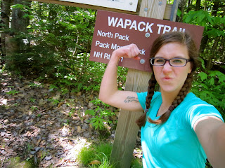
I concocted this plan almost immediately after the first time I hiked up Pack Monadnock last summer with two friends and saw the trail marker. My research on the trail quickly led to a moment of self-doubt, followed by bizarre justifications that did not apply to my life. It went something like this:

Ohhhh, 21 miles... that's a lot.
But I've hiked Pack Monadnock, and North Pack Monadnock (the last two of the trail), and I'm pretty confident over those mountains.
But seven mountains... damn.
But they're not that high.
BUT, 21 MILES.
People run marathons every day.
You do not run marathons. You do not run, period. Who the hell is going to do this with you?
Probably no one. I will do it alone.

21 miles is a lot. I don't know why I made the comparison to a marathon, because hiking 21 miles is a lot different than running 26.2. Just because people, freakishly fit people, can run 26.2 miles does not mean I am qualified to hike 21.4 miles over seven mountains, but I decided that I could. And after a few months of mulling over the idea, I also decided I was suited to hike it alone. In my defense, I did post a few general invitations via Facebook... apparently I'm not much of a saleswoman. With decent weather fast approaching, I made the decision that hiking alone was not a big deal. I'd done it plenty of times before, so what was the big difference? (Spoiler alert: it was a big difference).

I chose the second weekend in May, thinking that the temperatures would quickly start rising after that (though who knows with New England. It snowed in NH on Memorial Day). The week before was filled with giddy anticipation and mild dread. I had never been on a hike that required much thought or planning; I was used to just driving to the base, hiking up, snapping a few pictures, eating some trail mix, hiking back down, and going about my day. But, as any committed hiker knows, an all-day excursion warrants much more thought. How much water did I need? How much weight would I be carrying? What were the best foods to bring? What do I need to wear? How can I coordinate being dropped off and picked up? How much mileage can I actually cover in a day? Did I actually need that ridiculous pocket knife that my parents were insistent on me bringing? (Yes) Etc, etc, etc.

The night before the hike I read the hard copy of the trail guide, which luckily my parents had stashed away somewhere. One of the first lines was never "never hike alone". I said "oops", and then disregarded the suggestion with youthful, reckless abandon. Reading through the Flora and Fauna section brought up the topic of bears, and my youthful, reckless abandon was abruptly interrupted. In 18 years of living in southern NH, and 4 more spent back and forth between there and Boston, I had never seen a black bear. When my mom told me they had seen a black bear on Pack Monadnock, a mountain I frequently hike, my eyes bulged out of my head. I KNEW black bears were in our area but for some reason I never really thought about running into one in the woods.. which is absolutely foolish. I had watched video of black bears casually batting bird feeders around in people's yards in much more populated areas, why the hell did I never consider coming across a bear in its own habitat? Immediately, I flashed back to earlier in the day when I was buying a new rain jacket at Columbia. I asked a saleswoman for her opinion between three jackets I had picked out. She suggested the blue one I was holding "because it's so cute!". I did end up getting that one (not just for the color), and joked to several people that my hiking rain jacket was not a fashion statement, but maybe a bear would decide not to rip my face off if it saw I had fashionable rain gear. I had a discussion with my parents about what I would do if I saw a bear, and I concluded that I would die.

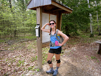
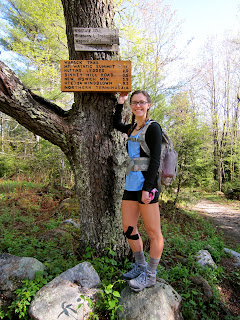
Beginning of the trail
I set out with my mom the morning of May 9th to Ashburnham, MA. I was feeling good from my favorite pre-strenuous day activity - carb loading. From my research and own experiences, I decided to load up on complex carbs (pasta) and protein the night before, which break down slowly and give you lasting energy. I brought a mix of food that would provide instant energy (simple carbs, PB & J, Snickers) and was easily packable (beef jerky, trail mix, energy bars). I also carried my camera, sunscreen, bug spray, light sweatshirt, trail guide, another map, knife, emergency first aid kit, water/Gatorade/VitaCoco totaling about 5.5 pounds, cell phone, license, pedometer, and enough knee braces & KT tape to open up a physical therapy office along the trail. As we pulled into the parking lot I realized I forgot my "trekking" poles, which are actually just old ski poles I found at the dump. It wasn't a trip-ruiner, but someone with my joints really benefits from the extra support. My mom got out of the car, swatted away a swarm of black flies, looked around, and said "I'm leaving you HERE? Alone? Oh... boy...." I responded "yup", left her with a detailed map and estimations of where I would be and when, snapped a picture, and headed off confidently into the woods. My poor mother. I think watching me trek into the forest alone shaved a few months off of her life.

I headed for the summit of Mt. Watatic, a modest but decent ascent. I was plodding along, enjoying my surroundings, feeling good, but suddenly I was filled with dread. The internal conversation went something like this: "What do you think you're doing? Why do you think you're qualified for this? You tore your meniscus trying to get out of the way of an opening door, why do you think your body is fit for this? What are you going to do if a bear mauls you? You're out here alone..... what's that noise? ........... IS THAT A FUCKING BEAR?!"  Indeed it was. Just as I was contemplating my fate, a pretty sizable black bear went galloping through the woods about 100 yards away. Thankfully it was running the opposite direction. I knew I was supposed to stand my ground when facing a black bear; give it space and respect but also make myself look big and imposing. Instead what I think I did was freeze, stare blankly, and think "well, this is how I'm going to die". I say 'what I think I did' because it's all a blur, really. Ever seen someone get tased? Their body locks up and they fall to the ground. That's essentially what my brain did, and I'm surprised my body didn't follow suit. The rush of adrenaline had my heart beating out of my chest, so much so that as I continued walking I thought the bear could probably hear it. I was so consumed by my imminent death that I slowed enough for a woman to catch up to me, and thank heavens she did. She heard the bear, too, but thought it was my dog. I wish. Talking and hiking with her to the top calmed me enough to avoid cardiac arrest. As soon as I got to the summit I took out the ridiculous knife I didn't think I would need and clipped it to the waist strap for easy access. It was a foolish sense of protection, but a sense of comfort nonetheless.

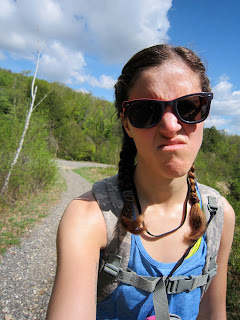
Lost on some logging road.
I wish I had enjoyed Mt. Watatic more. The black flies were so constant that I couldn't stand in one place for very long. The views were great, but I had to keep moving north to stay on schedule. I consulted the trail guide, which said the trail continued north via an unmarked footpath to the right of a fire tower, crossed under an abandoned ski lift after about 100 yards, then linked back up to the woods after about 1/2 mile. Easy enough, I thought, but as I looked around I realized there were about 5 unmarked footpaths and the fire tower did not exist anymore. Every map I looked at seemed to have the trail continuing down another side of the mountain, not doubling back on itself. I picked a footpath, followed it, second guessed myself, doubled back... picked another one, wound up in overgrown brush, doubled back.... found what looked like an old logging road, crossed under what could have either been an old ski lift or a power line, couldn't find the trail, doubled back...... well, you get the idea. In all I probably hiked up and down that mountain three times. I consulted the trail guide about 50 times. I turned on my phone to look at the website and see if I had missed something. I had not. I added about an hour and a half of time and ~4 miles. It was exhausting. I was waiting for the bear to pop back up at any moment. I wished I had someone with me just to bounce my thoughts off of. It was hot, I was constantly second-guessing myself, my muscles were already tiring, and I forgot to keep hydrated. I finally sat down, took a long drink of water, and decided to go back down the way I came. I trudged angrily down the mountain, but came to the conclusion that maybe today was not my day and I had to be okay with it. Maybe I had not done my homework well enough. Maybe I wasn't meant to hike today. Just as I was ready to admit defeat I saw a sign indicating Wapack North. I think I actually laughed out loud. I'm not sure if the trail guide is outdated (though there's updates on the website, and nothing about Mt. Watatic), or if the trail was rerouted, but I was not off to a great start.

The trail continues into New Ipswich, NH, through an area that looks like it's being cleared for construction. I thought there was no way they would be building anything out there (there's no roads! Literally, no roads!), but I saw a building permit on a tree. My success at finding the trail again combined with being in an open area with good visibility had me feeling good, but as soon as I re-entered the woods dread creeped up on me again. The mind can play amazing tricks on itself. Every tiny movement I heard in the woods caused my body to seize into a fight-or-flight response (or in my case, apparently, just stand there dumbfounded). I never did see that bear again, but the thought of it haunted me all day. I coped by singing one of my favorite Pearl Jam songs out loud.
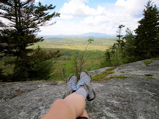
Binney Pond 
My next landmark was Binney Pond State Forest. Looking at Binney Pond felt like looking into the past. It was very secluded and I was the only one on the trail in the area. I got a sense that it had been unchanged for a long time. Unfortunately, I could not stop to enjoy it because I was behind schedule and being attacked by black flies. The climb up Pratt Mountain, the second of seven on the trail, was short but strenuous. It probably wouldn't have been so bad if I didn't hike up and down Mt. Watatic about three times, but it did give my legs a good burn. On the way up I was cursing myself: "This sucks. YOU did this to yourself. You can't even be mad. You're putting yourself through this on your own free will." The summit of Pratt Mt. is underwhelming. There is a viewpoint but I was too angry to take extra time for a viewpoint. I regret it.

Instead, I trudged on to New Ipswich Mt., a much less steep grade but essentially touching Pratt Mt.'s base. I descended Pratt Mt. and immediately ascended the next. New Ipswich Mt. had better views, so I stopped to let my legs rest for a few minutes. I recently saw a quote that said "summer is fun until every bug comes out of the 8th circle of hell", and it was quite fitting for this situation. I constantly had flies/mosquitos/who-knows-what buzzing in my ears, and staying still only made it worse. They persisted no matter how many times I coated myself in bug spray. Despite being eaten alive, I finally had a moment of peace that so often comes with getting to the top of a mountain. It was an absolutely beautiful, clear day, which made for great views. It was impossible not to appreciate. For a moment I forgot about how frustrating, and at times, scary, the morning had been up until that point. Then I looked at the surrounding area, realized I barely saw anything for miles and miles, and continued on before the thought of "I better not get injured out here" came back.

A few miles later came Barrett Mt., where I stopped and forced myself to eat my sandwich. I noticed I had zero appetite, which was the opposite of what I was expecting. Nevertheless, I knew with the constant movement, four mountains, and near 80 degree heat that I was burning a lot of calories (I burned about 3500 calories that day). After Barrett Mt. the trail crosses into the Windblown Cross Country Ski area, where several trails cross cross over the Wapack. Thankfully everything is extremely well marked, so it was easy to follow. I began to experience what I call balloon-brain. Balloon-brain is when I've been doing the same thing for a while and my brain seems to float out of my head and detach from the task, but my body continues to do it. I had been walking all day, and eventually I didn't even need to think about doing it anymore. My body took over and my brain was off somewhere else. I hadn't seen another soul for hours. I've read several books about long-distance hiking, and it seems I'm not the only one who experiences balloon-brain. It is oddly peaceful.

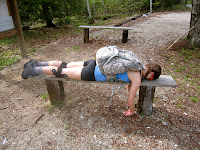
Blissfully horizontal

Popping out into civilization is always a weird phenomena when you've secluded in the woods all day. I knew I was getting close to the crossing of Rt. 123/124 because I began criss-crossing powerlines. I started to debate whether I should call it a day and have my mom pick me up there. I had done about 12 miles of hiking, more than I had ever done in a day. I turned on my cell phone, plopped down next to a powerline (ahh, nature), and called my mom. During our conversation I decided to push on to the next major road crossing. It didn't look that far... and it wasn't that far. But, damn, it felt far. I believe the trail was re-routed here, because the blazes disappeared for about a mile. Thankfully they popped up again and I was able to get back on the trail. It was ~4 miles of walking through wide, wet, and leafy trail. I reached the road I was meeting my mom on and to my dismay it was a hill. Not a particularly big hill, but after 16.81 miles of hiking it looked like Everest to me. My mom doesn't have a cell phone (hold your gasp), so I couldn't tell if she was already waiting for me at the parking lot. I agonized over the two options: I either walk up this stupid, annoying hill and hope she's already there, or wait where I know she has to drive past and avoid this stupid, annoying hill. I walked up the stupid, annoying hill. Thankfully she pulled in the moment I reached our meeting spot.

I spent a good portion of the day frustrated. I spent all of the day sweating bullets, aching, being attacked by bugs, and cursing my decision. I had no appetite. But the second I got into that car and ripped off my boots I joyfully recounted my day and ate an entire bag of beef jerky without realizing it (there's that balloon brain again). I've never experienced being sore BEFORE finishing a workout. 'Ol Faithful, my recurring blister-within-a-blister, was out in full force and accompanied by a few friends. I was happy, accomplished, and thinking "how the hell am I going to wake up and hike again tomorrow?". Thankfully for my muscles and 'Ol Faithful there was severe thunderstorms in the forecast the next day and I couldn't get out on the mountains. I was thankful for the rest but also incredibly frustrated. Going back to Boston without finishing the last section ate at me. My mom tried to reason with me ("you can finish soon, don't worry"), and I was only able to respond with disapproving grunt.

Summit of Pack Monadnock
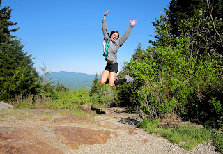
The next weekend brought another bout of bad thunderstorms, and the next was my graduation. I was itching to get back and finally got to 18 days after I started. I decided to skip a small section (Burton Peak and Temple Mt.) and start at Miller State Park in Peterborough, NH. The mileage I hiked would have put me further than Miller State Park had I been going the right direction the entire time. Pack Monadnock and North Pack Monadnock are two mountains I have hiked many times, but I never hiked the two together. They are both easy mountains with moderately strenuous sections, which makes it very crowded in the warm weather. I was glad I got an early start so I was not overwhelmed by tons of families.

The end!.... almost. 
A pleasant, 6 mile hike on a warm, clear day was a great end to this experience. I didn't finish it within two consecutive days like I planned, but I was happy to accomplish my goal. I posed with the trail marker and gave myself a pat on the back... then promptly gave myself a punch in the face. My mom offered to drop be off and pick me up, but I thought "nahhhh, I'll just walk back to the car, no biggie." I had done a particularly strenuous workout earlier that week after about 2 weeks of being a couch potato (damn you, allergies), so I started the day on sore legs. 5.5 hilly miles after hiking 6 miles over two mountains was not the best idea I've ever had. I did not reach my blissful, balloon-brain state, but instead was quite bored and annoyed with myself. I jogged sections of the road, much to the dismay of 'Ol Faithful, out of pure boredom. Finally making the loop back to Miller State Park was a beautiful thing. I actually gave myself a few fist pumps.

The Wapack Trail was my first true long distance hike. It was at times frustrating and intimidating, and at times beautiful and rewarding. Most of all, it was a learning experience. I had a moment when I was hot, dehydrated, sweaty, sore, and being eaten by bugs, and I said to myself "if you ever want to do this shit again, remember how you feel in this moment". I've already disregarded that and am looking forward to hiking this trail again in its proper form.... maybe this time with a friend.

A Useless Hobby

Hiking a useless hobby, really.

There's no tangible outcome with no audience. If you knit, you make a nice sweater. If you paint, you create a beautiful piece of art. If you sing, you entertain the crowd. If you hike, you walk around and spend hours climbing mountains. Maybe you get a nice picture and a story to tell every once in a while.

It's not that useful of a skill. Anyone can walk. Anyone can walk up a mountain, given enough time. It does not require a natural ability. Some people will say that you can become a great dancer with enough practice, but I promise you there is a natural talent and ability that makes someone a graceful dancer and some people will never have that (me included).

Hiking is often hard, sometimes dangerous, sometimes uncomfortable, sometimes boring. It leaves you sore, tired, blistered, and chaffed. A nice day can turn into a storm in an instant at higher elevations and can leave you drenched from head to toe. A huge range of plants and animals can, at the very least, give you a scare, and at the very worst, kill you. You often have to pee in the woods.

So why the hell do it?

I grew in up Southern New Hampshire, so naturally I was surrounded by the woods. I loved the outdoors as a kid, but in high school I was too consumed by teenage angst to care much about anything else. My ailing body is a running joke among my friends and family. I tore my meniscus and partially dislocated my kneecap two years ago by simply getting out of the way of an opening door. A month on crutches and 6 weeks of physical therapy was only the beginning. It took a year before I was fully healed.

After weeks of discomfort in my lower back I had another MRI and found out I had a bulging disc pressing up against my spine. I had a epidural cortisone injection in my spine and went back to physical therapy. In this round of physical therapy I found out I have mild scoliosis and a bone deformity in my hip that makes my left leg longer than my right; basically, I have been off balance for 22 years.

"I'm back!"
I didn't get back into hiking until last summer when I went out with two friends of mine. It was a small mountain, but getting to the top of it was extremely rewarding. I felt like I was finally back to normalcy (though I will forever need braces and PT), like I was strong and able. Anyone who has had an injury that takes a long time to heal knows what I mean. I saw the much larger Mount Monadnock from the summit of Pack Monadnock and set my sights there. It didn't take long to reach that goal, and my love for the outdoors has been reignited ever since.

So, why hike? Well, for me it provides a chance to detach from life while appreciating it at the same time. How often do you appreciate a really pretty tree? A nice view? A giant boulder in the middle of the woods? I've lived in Boston for the past 5 years, and as much as I love the city part of my heart is still in the woods of New Hampshire. Life in a city can get pretty monotonous, hectic, and suffocating at times. Getting out on a mountain is quite literally a breath of fresh air. It's a chance to sign offline, even if just for a few hours, and be blissfully detached. The miles of blood, sweat, and (figurative) tears are worth the view at the top. A lot of people do their best thinking in the shower, I do some of my best thinking trekking through the woods. Though I am no super-hiker, my experiences hiking in the past year have pushed my limits and showed me that I am capable of being a little tough. In a time when my life is up in the air, student loans are looming over my head, the pressure to get a job and make money is more significant than ever, my personal life isn't always steady, etc., climbing a mountain is something I CAN accomplish.

Welcome to my misadventures on mountains.